-
×
 NCERT Our Wondrous World Textbook of Environmental Studies for Class 3 (With Binding)
₹90
NCERT Our Wondrous World Textbook of Environmental Studies for Class 3 (With Binding)
₹90 -
×
 Full Marks English Complete Study Material Class 8 (Based on New NCERT Textbook POORVI and CBSE Syllabus)
₹450
Full Marks English Complete Study Material Class 8 (Based on New NCERT Textbook POORVI and CBSE Syllabus)
₹450 -
×
 U-Like English (Core), CBSE Chapterwise Question Bank For Class 12 2022-23
₹540
U-Like English (Core), CBSE Chapterwise Question Bank For Class 12 2022-23
₹540 -
×
 NCERT Curiosity Science Textbook for Class 7 (With Binding)
₹90
NCERT Curiosity Science Textbook for Class 7 (With Binding)
₹90 -
×
 Full Marks Geography Complete Study Material Class 11 (Based on Fundamentals of Physical Geography, India: Physical Environment, Practical Work in Geography)
₹430
Full Marks Geography Complete Study Material Class 11 (Based on Fundamentals of Physical Geography, India: Physical Environment, Practical Work in Geography)
₹430 -
×
 Oswaal CBSE Question Bank Chapterwise and Topicwise Solved Papers Class 12 Physics For Exam 2026
₹685
Oswaal CBSE Question Bank Chapterwise and Topicwise Solved Papers Class 12 Physics For Exam 2026
₹685 -
×
 Full Marks Psychology Complete Study Material Class 11 (Based on Latest NCERT Textbook Psychology and CBSE Syllabus)
₹340
Full Marks Psychology Complete Study Material Class 11 (Based on Latest NCERT Textbook Psychology and CBSE Syllabus)
₹340


Gowoo Big 100 Outline Maps (A4 Size) World Physical


₹110
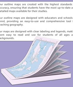
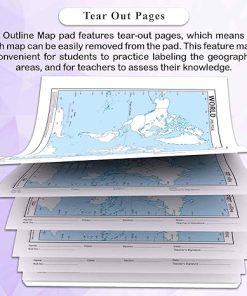
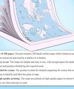
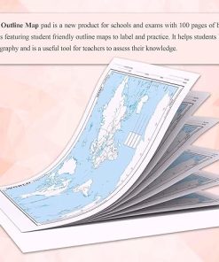
Introducing Gowoo’s BIG – 100 World Physical Outline Map for Schools, a fantastic educational tool that allows students to explore and understand the physical features of countries around the globe. With its generous size of 11*8.5 inch, this map provides ample space for students to delve into the captivating landscapes of our planet. Students can easily identify and differentiate these features through clear and simplified outlines, gaining a deeper understanding of the Earth’s diverse topography. One of the standout features of this map is its tearable paper design, which allows for easy distribution among students. Each student can have their own copy, enabling them to interact directly with the map. They can make personal notes, mark important locations, or use it as a reference during classroom discussions or individual research projects. Gowoo’s BIG – 100 World Physical Outline Map for Schools serves as a valuable resource for teachers aiming to teach students about the physical geography of different countries. By providing an accurate representation of the world’s physical features. Whether used in the classroom or for independent study, the BIG map serves as a captivating visual aid that engages students’ imagination. Its larger size allows for detailed observation of the physical characteristics of various countries. The BIG map encourages a comprehensive exploration of the world’s physical geography. Gowoo’s BIG – 100 World Physical Outline Map for Schools goes beyond the boundaries of the classroom, empowering students to embark on personal adventures of discovery. Its tearable paper design allows for easy portability, making it suitable for field trips or personal exploration. Students can delve deeper into the physical landscapes of different countries, expanding their knowledge and fostering a sense of interconnectedness with the world. Gowoo’s BIG – 100 World Physical Outline Map for Schools is an invaluable resource that enables students to explore and understand the physical features of our planet in an engaging and accessible way. With its larger size, tearable paper design, and emphasis on essential information, this map enriches the learning experience, igniting curiosity and promoting a deeper appreciation for the diverse physical landscapes that shape our world.
Introducing Gowoo’s BIG – 100 World Physical Outline Map for Schools, a fantastic educational tool that allows students to explore and understand the physical features of countries around the globe. With its generous size of 11*8.5 inch, this map provides ample space for students to delve into the captivating landscapes of our planet. Students can easily identify and differentiate these features through clear and simplified outlines, gaining a deeper understanding of the Earth’s diverse topography. One of the standout features of this map is its tearable paper design, which allows for easy distribution among students. Each student can have their own copy, enabling them to interact directly with the map. They can make personal notes, mark important locations, or use it as a reference during classroom discussions or individual research projects. Gowoo’s BIG – 100 World Physical Outline Map for Schools serves as a valuable resource for teachers aiming to teach students about the physical geography of different countries. By providing an accurate representation of the world’s physical features. Whether used in the classroom or for independent study, the BIG map serves as a captivating visual aid that engages students’ imagination. Its larger size allows for detailed observation of the physical characteristics of various countries. The BIG map encourages a comprehensive exploration of the world’s physical geography. Gowoo’s BIG – 100 World Physical Outline Map for Schools goes beyond the boundaries of the classroom, empowering students to embark on personal adventures of discovery. Its tearable paper design allows for easy portability, making it suitable for field trips or personal exploration. Students can delve deeper into the physical landscapes of different countries, expanding their knowledge and fostering a sense of interconnectedness with the world. Gowoo’s BIG – 100 World Physical Outline Map for Schools is an invaluable resource that enables students to explore and understand the physical features of our planet in an engaging and accessible way. With its larger size, tearable paper design, and emphasis on essential information, this map enriches the learning experience, igniting curiosity and promoting a deeper appreciation for the diverse physical landscapes that shape our world.
Related products
-2%
Original price was: ₹440.₹430Current price is: ₹430.
-1%

Original price was: ₹596.₹590Current price is: ₹590.
-2%
Original price was: ₹348.₹340Current price is: ₹340.
-2%

Original price was: ₹520.₹510Current price is: ₹510.
-2%

Original price was: ₹520.₹510Current price is: ₹510.
-2%
Original price was: ₹396.₹390Current price is: ₹390.
Out of stock
-2%

Original price was: ₹496.₹485Current price is: ₹485.